
While conducting levelling in the survey, different types of levelling problems are encountered which makes it difficult. Levelling is a fundamental technique in surveying that allows us to determine the height differences between different points on the Earth’s surface. While it may seem straightforward there are several challenges that civil engineers face during the levelling process. During the levelling process, obstacles from various ground conditions, natural formations, and man-made constructions frequently arise. In this article, we will explore these challenges and discuss practical solutions to resolve them. Here are some methods to consider while facing levelling problems in surveying.
Different Types of Levelling Problems that Make Levelling Difficult
There are numerous problems that surveyors may encounter during levelling. These include the following:
- The surveying staff is too close to the instrument.
- Levelling across a large body of water like a lake.
- Levelling across a flowing body of water like a river.
- Levelling across a solid barrier such as a wall.
- Benchmarks that are above the line of collimation.
- Levelling along steep slopes.
- Levelling across uneven or changing ground levels.
Levelling Problem 1: The surveying staff is too close to the instrument
Sometimes, the leveling staff might need to be placed very close to the instrument. This can cause a loss of focus in the instrument and create blurry images. This situation can bring about difficulties in recording the staff readings accurately, especially if the staff is closer than the instrument’s focusing limit. One simple solution involves using white paper. By slowly moving a white paper up and down in front of the vertically held staff, you can determine the correct point of collimation when the edge of the paper is viewed through the instrument’s scope.
Levelling Problem 2: Leveling Across a Large Lake
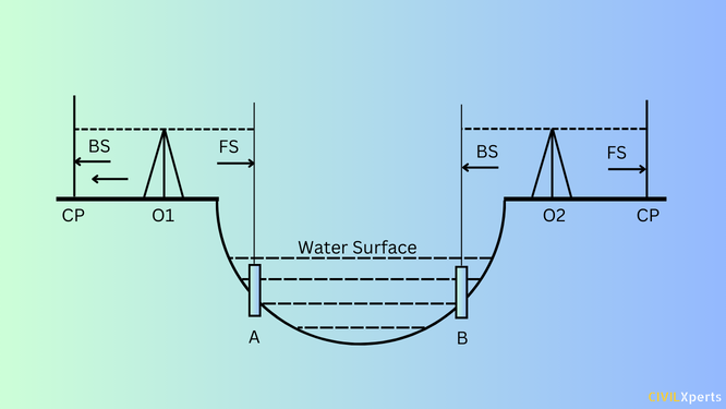
Crossing a large lake or pond can pose quite a challenge for most surveyors. In this situation, certain assumptions must be made to make the process possible. Since the water in a lake or pond is typically still, it can be considered a level surface. Staff can be positioned on either bank of the lake, with the top of the staff visible above the water. Then, measure the Reduced Level (RL) at the first peg with a foresight (FS) reading. Assume that the RL at the second peg is the same as at the first peg. Move the instrument to the other side and take a back-sight (BS) reading from the second peg.
Levelling Problem 3: Leveling Across a River
Surveying across a river can be challenging because of the water’s constant flow, which results in different water levels at each riverbank. In such cases, you can use the reciprocal method of leveling.
Place pegs on both banks of the river and measure the RL at the first peg using standard methods. Measure the RL at the second peg, finding the true difference in levels between the two pegs using reciprocal leveling.
Levelling Problem 4: Leveling Across a Solid Wall
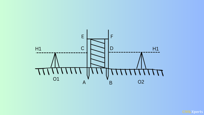
When leveling across a solid wall, it is difficult to establish benchmarks on both sides. For this type of problem in levelling an alternative method called “differential leveling” can be employed. This involves setting up the instrument on one side of the wall and measuring the height difference between the benchmark on the visible side and the points of interest on the other side of the wall. Drive pegs on both sides of the wall, with the staff just touching the wall. Measure the height of the instrument by focusing on a benchmark or a reference point.
Note the staff reading on one side of the wall. Then, measure the height of the wall using the staff. With this data, you can calculate the RL of every point along the wall. Repeat this process on the other side of the wall if needed.
Levelling Problem 5: Benchmark lies Above the Line of Collimation
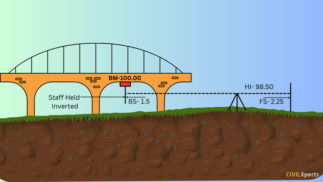
If the benchmark is situated above the line of collimation, for example, under a bridge girder or a culvert, it presents a challenge. You can find a solution to this problem by taking the foresight (FS) reading for point A with the level positioned at O. Hold the staff under the girder in an inverted position at the benchmark. Note the back-sight (BS) reading from the inverted staff and indicate it with a negative sign in the remarks column, stating “staff held inverted.”
Levelling Problem 6: Leveling Along Steep Slope
In hilly regions or steep slopes, achieving consistent back-sight and foresight readings can be tricky. You can address this issue by setting up the level in zigzag paths. Position the instrument in a zigzag path in a way that back-sight and foresight readings are equal. Calculate the RL of each point along this zigzag path. This approach works for both positively and negatively inclined slopes.
Levelling Problem 7: Leveling Across Depression or Rising Ground
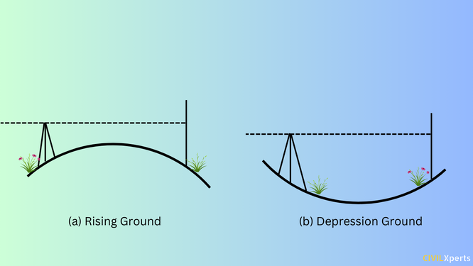
When the ground surface has rising and depressions it becomes difficult to establish a continuous line of sight. For rising ground, place the instrument so that the line of collimation passes through the highest point. For depressed ground, position the instrument on one side of the depression, with the staff on the other side.
Conclusion
Surveying and leveling are essential components of civil engineering that help in the planning and execution of construction projects. While leveling can present various challenges due to natural and man-made obstacles, understanding these levelling problems and employing practical solutions is necessary for achieving accurate survey results. By following the provided solutions, you can improve the accuracy of your leveling measurements and ensure the success of your surveying projects.
FAQs
Q: What is the purpose of levelling in surveying?
The purpose of leveling involves the measurement of elevation differences between points on the surface of the earth. It is used to find the elevation of given points with respect to the given or assumed datum.
Q: What is the full form of RL in levelling?
In surveying, (RL) means the Reduced Level which shows the vertical difference between the survey points and the adopted datum surface.
Q: What is BS in surveying?
BS stands for backsight. It is the first reading taken by the surveyor after setting the instrument. BS is generally taken on the point whose RL is known.
Q: What is a benchmark in leveling?
A benchmark is a reference point with a known elevation used as a starting point for leveling surveys. It can be used to verify the other points.
You may also like to read:
Auto Level Parts | Step-by-Step Guide for Beginners|

5 Best Types of Measuring Tapes For Engineers
